Trombay
EditWatch this pageRead in another language
Trombay
Trombaysuburb
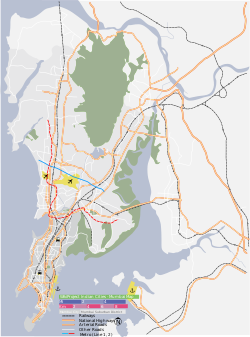

Trombay
Location in Mumbai, IndiaCoordinates: 19.0°N 72.9°ECountry IndiaStateMaharashtraDistrictMumbai SuburbanMetroMumbaiLanguages • OfficialMarathiTime zoneIST (UTC+5:30)
Trombay is a northeastern suburb in Mumbai, India, with Mankhurd as the closest railway station on the Harbour Line of the Mumbai Suburban Railway.
HistoryEdit
Trombay was called Neat's Tongue because of its shape. Once, it was an island nearly 5 km East of Mumbai and was about 8 km in length and 8 km in width. The island contains several ruins of Portuguese churches from the 1620s and 1630s.[1]
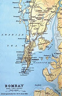


1893 map showing Trombay
In 1928, the Great Indian Peninsular Railway opened the Trombay-Andheri line called the Salsette Trombay Railway or Central Salsette Tramway.[2]
The original inhabitants of Trombay were fisherman (Kolis) - due to its proximity to the Thane creek and the Arabian Sea. It was called as "Turbhe" (not to be confused with another area called Turbhe in Navi Mumbai) in the local language. Dattanagar, It is a leprosy colony near trombay. Paylipada, near Trombay Village, is also very old, having one of the oldest masjid in Mumbai.Trombay gaothan is old village of Koli family. Paylipada has majority Muslim population. In 1976, the Janata Colony area was relocated by BARC by order of the central government and formed as Cheetah Camp.
DemographicsEdit
Starting out as an industrial area, Trombay is still known more for its industries than a residential suburb but this is fast changing. Trombay has a cosmopolitan population that is dominated by Tamilians and Maharashtrians followed by Keralites, Punjabis, Sindhis and Gujaratis.most of fishermen(koli) and agri people are staying in trombay
Anushakti Nagar is the residential colony of Bhabha Atomic Research Centre.
Landmarks
See also
Post a Comment